Windstorms, Puget Sound and the Northwest
By Michael FaginHistorical Weather Data, Weather ConditionsWith 0 commentsWindstorms, Puget Sound and the Northwest come from two prominent sources: gap winds and extratropical cyclones. Gap winds are caused by a funneling of high pressure, continental air through valleys into zones of low pressure. Sometimes incredible winds can result, such as at Bellingham, WA, which has endured gusts around 115 mph when air traverses southwest from continental Canada through the Fraser River valley.
Catastrophic winds are more commonly from extratropical cyclones, which differ from hurricanes because they aren’t tropical and don’t behave tropically; yet, they can match Category 3 hurricanes in sustained wind speeds and core pressures. The Puget Lowlands are vulnerable to extratropical cyclones that push into the Olympic Peninsula. There are many extratropical cyclones on record but we shall observe a particularly notable three.
A moderately snowy March 12-13, 1993 storm was bestowed the title “storm of the century” but it realistically paled in comparison to the Oct. 12, 1962 Columbus Day storm. The monstrosity delivered the legendary “Big Blow,” which destroyed $230-280 million in property along the Pacific coast. In the Northwest Oregon town of Lake Oswego, 70% of the approximately 4,000 houses were damaged. The intensity of the Columbus Day windstorm was drawn from the remains of a dying Typhoon Freda. Eventually, the previously ailing cyclone dipped to 960 mb, which was deep but not particularly impressive relative to some other major extratropical cyclones. A wind gust of 138 mph was seen in Newport, OR. The merging systems followed the “Classic Path” of Northwestern extratropical cyclones, which includes tracking offshore from the southeast and crashing into Vancouver Island.
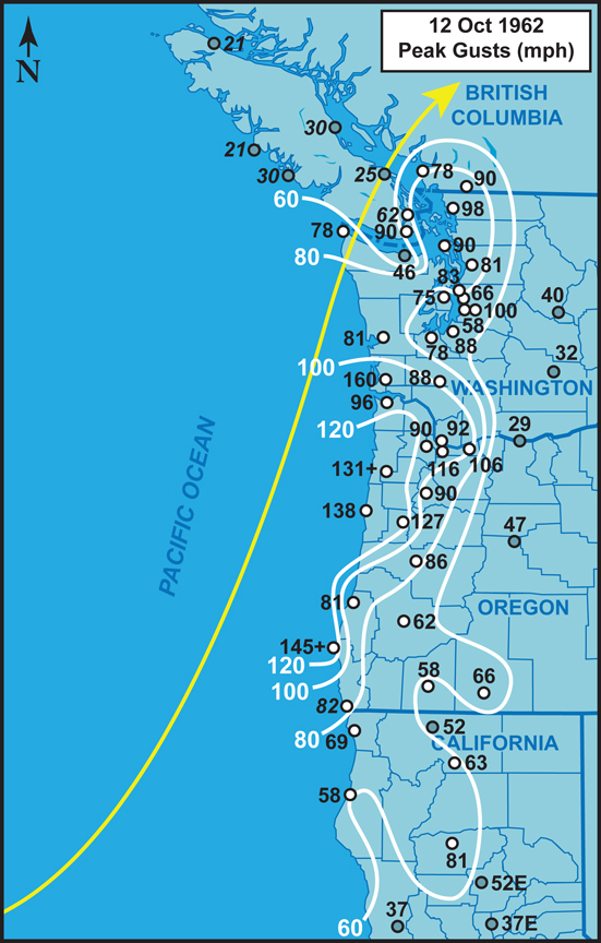
Peak Winds. Credit Wolf Read
Another notable system, the strongest since the Columbus Day windstorm, bombarded Washington on January 20th, 1993 Inauguration Day. It only dipped to 967 mb and had moderate winds for a major extratropical cyclone but still managed to pack a solid punch. Tillamook, OR saw a 98 mph gust and Boeing Field felt a 70 mph gale: its strongest since Oct. 21. 1934. The Inauguration Day windstorm delivered widespread damage to homes and left ¾ million without power. $130 million in property was claimed. Falling trees killed three and another perished from a downed power line.
In the past decade, the December 14-16, 2006 Hanukkah Eve windstorm grew more powerful than both. A 957 mb Low that made landfall at the Queen Charlotte Islands fed an extratropical cyclone that pushed inland from near the coast of southern Oregon. It brought devastating winds to Northern California, all the way up the coast to Vancouver Island. An historic 155 mph gust was recorded at Estevan Point, British Columbia. 115 mph was witnessed on the central oceanic coast of Vancouver Island. Sea-Tac airport reported 69 mph winds. Some areas close to Seattle experienced record rainfall rates that peaked around an inch per hour. The already saturated soil combined with heavy rains and strong winds to cause widespread tree uprooting. The Hanukkah Eve windstorm also followed the “classic path” that offshore-tracking southeasters take and crashed into Vancouver Island. The cyclone formed a bent-back occlusion, which pushed inland over Washington and dropped what became known as “The Surge.” The moisture-rich storm further challenged the notion that windstorms in the region tend to be dry. Storm details.
Respectable time and energy has been put into understanding the extratropical cyclones that hit Puget Sound and the Northwest. Among the different sources of research, a University of Vancouver thesis well discussed windstorms and their related damage near Puget Sound. An historical overview, climatological and synoptic environmental assessment of the major extratropical cyclones of the northwest United States is also available. Damaging windstorms will continue to pummel Puget Sound and the Northwest most every year. A better understanding of how they form and move may save millions in property and perhaps also lives.
Written by Meteorologist Geoff Linsley