El Niño
By Michael FaginGeneral Info, Historical Weather DataWith 0 commentsEl Niño. Will Summer 2017’s El Niño intensify severe weather in the US? Perhaps, if and when it does arrive.
The El Niño Southern Oscillation (ENSO) has been Neutral (within 0.5°C of the mean annual temperature) since January and will most likely stay the same through at least June. We’re in the spring ENSO predictability barrier, wherein, until the arrival of summer, the accuracy of models particularly suffers. The complication is largely due to the transitory nature of ENSO during the spring, when shifts between La Niña, Neutral and El Niño are particularly common. Properly taken with a grain of salt, the probability distribution for September 2017 is presently: 50% El Niño, 40% Neutral and 10% La Niña.
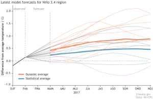
El Nino forecast
Statistical models – based on numbers from previous events – are leaning toward nearly Neutral conditions, while dynamic models – computerized projections of future weather – favor a weak El Niño (+0.5°C) coming as early as May.
Which should be taken more seriously? Statistical models largely hinge on the relative familiarity of the conditions seen during past events and, other than the eastern Pacific being sufficiently warm, the Pacific Ocean is presently not like normal pre-El Niño conditions. Surface winds over the west central Pacific are blowing stronger, instead of the weakening of the Walker circulation seen during past El Niños. Upper-level convergence and easterly low-level winds are causing a resistance of heat transfer from the warmer western Pacific. The weather is causing conditions more like La Niña to linger in the equatorial central Pacific. Additionally, dynamic models tend to fare better through the spring ENSO predictability barrier.
Will Summer 2017’s El Niño Intensify Severe Weather in the US and How Does El Niño Influence American Summers?
El Niño does affect summertime weather, just not as much and as predictably as wintertime weather. Every El Niño event is unique, so comparing current observations to past events is only mildly fruitful. Many recent events, however, have shown a pattern of a wetter tornado alley and northeast US, with particularly drier weather east and south of those zones.
El Niño, however, doesn’t always lead to a wetter tornado alley. The dust storms of the early to mid-1930s, including the infamous Dust Bowl, occurred after the drying that took place during 1931’s El Niño.
When it does arrive, how is the weather impacted? The Californian and Mexican coastal waters get warmer; and some of it becomes additional atmospheric heat and moisture, which feeds inclement weather downstream.
Dryness, however, doesn’t necessarily set aside the threat of severe weather. Abnormally hot and dry weather dries up groundwater quickly; and the temperature contrast between hot American air and cool Canadian air can lead to extra severe weather late in the spring and early on during the summer.
Hurricane formation is also affected by El Niños. More come from the Pacific Ocean due to reduced vertical wind shear, which helps to maintain the structure and persistence of the atmospheric engine fueling the weather system. Stronger vertical shear in the Atlantic Ocean acts to reduce the threat of Atlantic Hurricanes.
One storied aspect of American summers is tragedies to property during severe weather. El Niño-enhanced severe weather logically can lead to amplified insurance claim compensations. It is difficult to compare normality with the effects from El Niño but basic statistics can be used to infer general insights. Damages from severe storms were estimated at over $10 billion in 2015, which marked the eighth consecutive year of damages over $10 billion. Many years exceed $30 billion, with occasionally much worse years such as 2005, when over $200 billion in damages was racked (around 75% having been from nightmare Hurricane Katrina.) Years when El Niño encourages the production of severe weather may add billions to annual totals, largely dependent on the characteristic vulnerabilities of the areas struck.
National Outlook for May-July
According to NOAA, the next three months will bring above normal rainfall over and around the Rockies, and to the Western Gulf region, but below normal near the Great Lakes. Temperatures will likely be warmer than average everywhere but North Dakota, northwestern South Dakota and Montana. The Sun Belt and East Coast states will be the most likely to be hotter than normal.
Written by Meteorologist Geoff Linsley
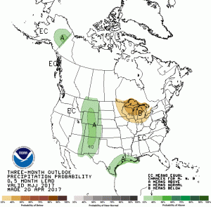
El Niño rainfall departure from normal
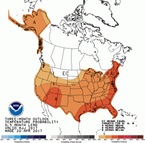
El Niño temperature departure from normal