La Niña Winter. 2017-18 Northwest Cascade snow outlook. Want snow? It’s shaping up to be a good late autumn and winter for an abundance to cover the slopes of Washington’s Olympics and Cascades. It’s time for ski resorts and skiers alike to get ready. El Niño-Southern Oscillation (ENSO) prediction ensemble members are agreeing on cool temperatures in the mid-Pacific yielding either temperatures on the cold end of typical or a weak La Niña event this autumn.

La Niña Winter Snow Cascades
Just months ago, the tropical waters in the central Pacific were warmer and models were predicting even more warmth. Recent cooling stretching from east of Australia to Peru has went in step with models now predicting a longer cooling trend. Subsurface ocean temperatures have also cooled, adding depth and longevity to the cooling of the surface – where the weather meets the water.
An official Climate Prediction Center/NCEP/NWS La Niña watch has already been issued. Just a few decades ago, such an issuance would have signaled little to nothing to both the general public and meteorologists. Today, weather scientists are able to compare observed details with ongoing ENSO records dating back to the late 1940s to attempt to frame what the general change does to individual regions. La Niña – cooler temperatures, 0.5°C below normal, in the middle of the Pacific Ocean – historically brings the mountains of the Pacific Northwest above average snowfall
Long-term ENSO forecasts are highly volatile but models presently suggest a lightening of La Niña conditions coming this winter. What does that mean for the Pacific Northwest? It could lead to less precipitation than otherwise but, around 85% of the time, strong autumnal La Niñas foretell colder than average winter temperatures. The average minimum temperature for some of western Washington’s major cities is around 15°F. The average temperature during eight recent winters when there was a strong La Niña were closer to 11.5°F. Over eight of the recent strong El Niño winters, an average of 20.3°F was recorded.
How Much Snow?
Will this year’s snowfall be like last year’s? It snowed a lot last year so totals may be hard to beat; however, late fall 2017 and winter 2018 may be similar.
How will it compare to previous winter La Niñas? It can be very snowy without breaking a record but it has snowed far more than what is expected for 2017-18. Mt. Baker Ski Resort in northwestern Washington is the world record holder for seasonal snowfall: 1998-1999’s 1,140’’ – when a strong La Niña helped bury what officially became the world’s snowiest mountain. The surplus of water vapor from the Pacific combined with consistently abnormally low freezing levels to preserve what fell throughout the season.
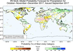
La Niña Winter and Snow photo credit CPC
The average placement of the jet stream has a great deal to do with what kinds of weather will be seen. On average, it’s slated to be over western Washington, which can encourage storm formation, orographic uplift and precipitation. As it’s looking like it will be a slightly colder than average winter for the Pacific Northwest, more of it than normal should fall as snow and less should melt. The other northern states are also slated to see extra. Far below the jet stream, California isn’t expected to see the abundance of snowfall and rainfall, which won’t help the catastrophic wildfires burning there.
If one takes the data from Mt. Rainier at Paradise the average snowfall is 640 inches and during the last 7 strong La Nina’s the average snowfall has been 862 inches. Will this be the trend for this season?
Is the End of the ENSO Phase in Sight?
Current models foretell the projected La Niña event will end in late winter or spring 2018, when it presently appears conditions will shift to ENSO neutral. Long-term ENSO models, however, don’t have a convincing history of accuracy and should always be taken with a grain of salt. The best strategy for preparing for ENSO changes is to keep up-to-date with the latest monthly model calculations and assessments, as periodically reported by West Coast Weather.
La Nina Winter
Written by Meteorologist Geoff Linsley