Understanding the Global Wind Oscillation enhances tornado forecasting
By Michael FaginTornado DamageWith 0 commentsTornado warning and understanding global winds patterns enhances tornado forecasting. Over the past month, meteorology professor at the College of DuPage near Chicago, Victor Gensini has been popularized for mixing existing prediction methods with a global circulation index. The Global Wind Oscillation (GWO) describes the addition of tropical moisture and energies through atmospheric channels, which enhance the probability that storms can evolve into a state that favors tornado production.
Oscillations and Impacts on Weather
The Global Wind Oscillation is a combination of several parameters, including El Niño, La Niña, the tropical Madden Julian Oscillation, and mid-latitude processes, such as troughing and ridging induced by mountain torques and meridional momentum transports. The global wind oscillation is mainly driven by mid-latitude mountain wave forcing and zonal wave energy dispersion.
The Madden Julian Oscillation (MJO) measures bridges of weather and climate forced into the mid-latitudes by the transport of tropical convection. Atmospheric angular momentum (AAM) is strongest when MJO anomalies near the International Dateline are weakening. The MJO’s meridional dispersion of Rossby waves is prominent, while the GWO is dominated by global Rossby wave dispersion.
The GWO examines a complicated mesh of wave patterns that shift every 40-60 days. For example, global frictional torque takes about 6 days to decay. The Madden Julian Oscillation (MJO) occurs every 30-60 days. The GWO attempts to combine the information provided by its encompassed parameters into one index that attempts to newly describe some of the Earth’s bonus points for tornado production.
Last year, Gensini accurately forecast ten tornadoes three weeks in advance, with a 66.7% overall success rate. It is important to mention that his success rate is related to the predicted production of tornadoes over an area of tens to hundreds of square miles. Predicting tornadic events is one level of success. Predicting them down to the level of about a square mile will be key in the future pursuit of accurately forecasting tornadoes.
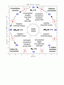
Global wind circulation and tornado warning. Diagram credit ossfoundation.us
Written by Meteorologist Geoff Linsley