Stormwater Weather Forecasting
By Michael FaginStormwaterWith 0 commentsStormwater Weather Forecasting- Stormwater test based on the weather forecast. The decision is a go or no go. In this case they need at least 0.50 inches (rain event) of rain in a 24 hour period and the location is just slightly north of Downtown Seattle. Also the engineering firm would like a 3 day notice of the potential rain event so they can plan according.
Go or No Go
On Sunday we look at several different forecast models (5 in total) and several of the national models suggest up an to 1.00 of rain for Seattle for Wednesday. However we look at several of the local models (2 MM 5 models from U. of Washington-UW) and they bring rainfall totals at 0.40 inches. Also the National Weather Service – Seattle Office (NWS) also has close to 0.40 inches for Seattle. We notify the client of this and they do not want to commit to chase this event at this point however they still want updates.
We tell our client that it is common that the national models “generally” tend to overstate the rainfall. Why, with a west to southwest wind flow much of Seattle can be in the rainshadow as the Olympic Mountains tend to do this. The Olympics tend to receive lots of rainfall leaving Seattle with much-much lighter amounts. Then as the windflow goes into the eastside foothills those regions (Redmond-Issaquah) tend to have much higher rainfall amounts than Downtown Seattle. See map below.
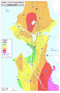
rainshadow- Photo Credit: The Urbanist
Then we take a look at the forecast models on Monday and the national models continue with 1.00 inch of rain for the Seattle for Wednesday . Also of interest is now the NWS has increased their forecast to 1.00 inch. However the 2 MM 5 local models still have 0.40 inches for downtown Seattle and 1.00 inch for Bellevue and Issaquah. Looking at some of details of the models they show surface winds and winds at 5000 foot level from the west to southwest which tends to bring the rainshadow to Seattle.
Based on this the engineering firm does not want to deploy their crew as the odds are not high enough of getting that the required 0.50 inches of rain in 24 hours. However, they request that we continue to monitor this for stormwater testing.
On Tuesday the 2 national models have increased totals to 1.5 inches for Seattle for Wednesday and the NWS has done the same. Another interesting fact is the one of the MM 5 models has now increased rainfall the rainfall to 1.00 inch for Seattle. However the other MM 5 model still only has 0.40 inches for Seattle. With this new information the engineering firm has increased interest in deploying their crew for this rain event. The firm goes on to say they are “real” interested in chasing this storm since it’s been so dry in Seattle they need to try to chase a “rain event.” With that in mind I suggest taking one last look at the forecast model updates on Tuesday night before making a final decision on if they should deploy for a stormwater test.
Tuesday night we see more changes and looking at the forecast maps we see all models showing a more southerly wind flow (usually means less of a rainshadow for Seattle). We now see that all 5 models forecast over 1.00 of rain during the day on Thursday for Seattle. Also of note there is 2.00 inches of rain forecasted for many of the eastside suburbs.
In summary, the client was able to get a successful test in. This final decision was “relatively” easy once we saw the final forecast models on Tuesday night. Then all models showed some heavy rain. Of course the decision is much harder when we have a more marginal situation of models showing close to the “rain event” threshold of 0.50 inches. When this happens then the client needs to decide how critical it is to get a test in now, what are the chances of more rain events in the near future. These are just some of the considerations.
Article written by Operational Meteorologist Michael Fagin