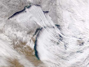
Heavy lake-effect snowfalls
By Michael FaginGeneral Info, Poor Visibility, Weather for PilotsWith 0 commentsHeavy lake-effect snowfalls can shut down entire cities and drastically impede our ways of living. In particularly prone areas, feet of lake-effect snow can arrive within a day and pin people indoors.
The mechanisms that manifest lake-effect snow can be thought of as components of a unified atmospheric machine. Its creation begins when wind meets the water and steam fog is created. As the wind continues to blow, more and more steam fog is generated and its lighter density than dry air causes it to lift. Eventually, this warm, moist air sufficiently collects, manifesting storm cells. Heavy snowfalls may occur depending on the development of the cells.
Several factors need to be considered when predicting lake-effect snows. The fetch – the stretch of the lake undergoing evaporation – needs to be at least fifty miles long to create substantial storm cells and heavy snowfalls. The longer the fetch, the higher the possibility and intensity of lake-effect snow.
Moisture-laden air upstream makes the process easier. Lake-effect snow is often called lake-enhanced snow when a system that’s already bringing moisture-laden air is introduced, intensifying snowfalls. Also, instability and wind shear add to the vertical motion of evaporating water vapor, enhancing snow totals. Large-scale (synoptic-scale) forcing from continent-sprawling storm systems provides the steady winds needed for meaningful sustained evaporation.
As storms blow inland, additional lift from heightened elevations and also the convergence of air from the slowing of the sea breeze over the rougher landscape both encourage precipitation. Local uplift often dictates the locations hit by lake-effect snows by confining them into narrow bands parallel to the prevailing winds.
Reducing the chance of lake-effect snow, preexisting snow and ice cover may inhibit temperature contrasts and thus evaporation.
Prevailing easterly winds make the eastern sides of the Great Lakes particularly vulnerable to lake-effect snowfalls. Cold air churns the warm Lakes, which retain summer heat much longer than does the air. The greater the temperature contrast between the air and the water, the higher the chance for lake-effect snow showers of all intensities, so conditions are prime between November and January. By late winter, the Lakes cool and their thermal contrast with the air lessens, which discourages evaporation and thus lake-effect snow. Together, the expansive Great Lakes are the world’s best lake-effect snow factory.
Given the appropriate conditions, lake-effect snows can manifest elsewhere, such as around the Great Salt Lake, the Baltic Sea, the Caspian Sea and the Black Sea. Ocean-effect, a.k.a. bay-effect, snows involve the same principles and are common in, for example, Cape Cod, MA, the western coast of Japan and Russia’s Kamchatka Peninsula.
Aircraft need be aware of the masses of supercooled (below 32°F) water that freeze into snow near the shoreline to help prevent heavy wing icing. Heavy snowfalls can reduce visibility to dangerous levels very quickly, which may hinder takeoffs and landings. Strong, persistent lake-effect snows can shut down airports for days on end, impeding flights, as well as imports such as basic supplies. Incoming flights are told to stall by flying around airports until they’re ready to accommodate landings, so the process of adequately refueling aircraft can deplete fuel stores faster than expected, which, until remedied, may delay future flights.
Picture below is satellite image of the lake-effect snow on 11/30/2004, courtesy of NASA
Article written by Meteorologist Geoff Linsley

