El Nino & Snow Washington Cascades
By Michael FaginGeneral InfoWith 0 comments
Photo credit: By Ali Swenson, John Walsh | Takepart.com
Introduction- Old Farmers Almanac Says
El Nino & Snow Washington Cascades is a phase that tends to frighten skiers since below normal snowfall usually occurs. However, do not despair (I think), according to the Old Farmers Almanac: “Winter (Northwest) will be cooler and rainier than normal, with above-normal snowfall. The stormiest periods will be throughout November and in early to mid- and mid- to late December, early January, and early March. The coldest periods will be in mid- and late December, late January, and mid- to late February, with the snowiest periods in mid-December, early to mid-January, and mid- to late February.”
How accurate is the Almanac? Well one meteorologist stated when asked the question: “The ability to predict events that far in advance is zero,” There’s no proven skill, there’s no technique that’s agreed upon in science to be able to do that.” Several other meteorologist have similar opinions. We better look at other sources.
What Is El Nino
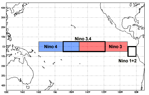
3.4 El Nino region Photo Credit: NOAA
El Nino occurs when the sea surface temperatures (SST) of at least 0.5°C (0.9°F) of above normal occur in the east-central Pacific (El Nino Region 3.4) for at least three months. El Niño is a phase of the El Niño/Southern Oscillation (ENSO).
El Nino Current and Forecasted Conditions
According to the Climate Prediction Center (CPC- branch of NOAA) there is a 95% chance that the current El Nino phase we are in will continue through the winter of 2015-16.
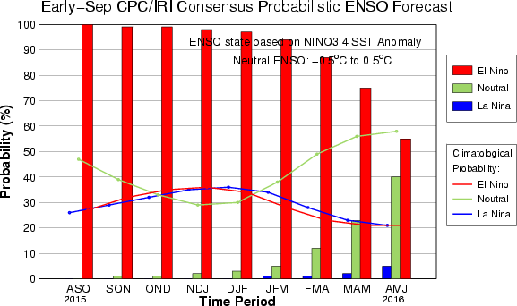
Probably of El Nino: Source Climate Prediction Center
As of the first week of October 2015 the current SST are at 2.3 C (4 F) above normal which is a strong El Nino and most models forecast this level will remain strong for most of the winter.

Winter Outlook El Nino. Source: International Research Institute (IRI)
To get a historical perspective the of the last strong El Nino events for 1982-83 had SST of 2.1 C above normal while the one in 1997-98 had 2.3 C above normal SST. Some of the models have SST of 3 C above normal for this winter thus the media has coined this:“GODZILLA EL NINO”
What Does It Mean For Snowfall For the Washington Cascades
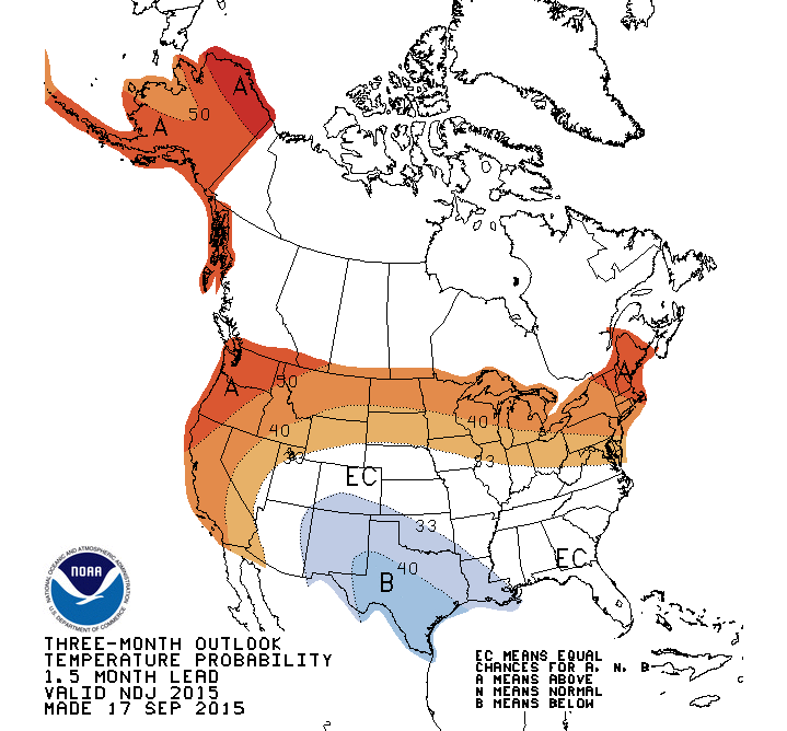
Forecast for Nov-Dec-Jan of 2015 is for above normal temperatures and below normal prec (graph not shown) Source: CPC
Usually a strong El Nino brings above normal temperatures and below normal precipitation for the Northwest, however even with this pattern the Pacific Northwest will normally have about 80% of normal snowpack, which is not that bad in the big picture. Keep in mind the winter of 2014-2015 much of the Pacific Northwest had 20% of normal snowpack and we were not in an El Nino phase. The main impact of a strong El Nino will be to shift the jet stream and associated storm track which is normally over the Pacific Northwest and shift it southward.
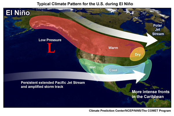
Jet stream is usually aimed at California during a strong El Nino. Source: UCAR
What Happens to Snowfall in Washington Cascades
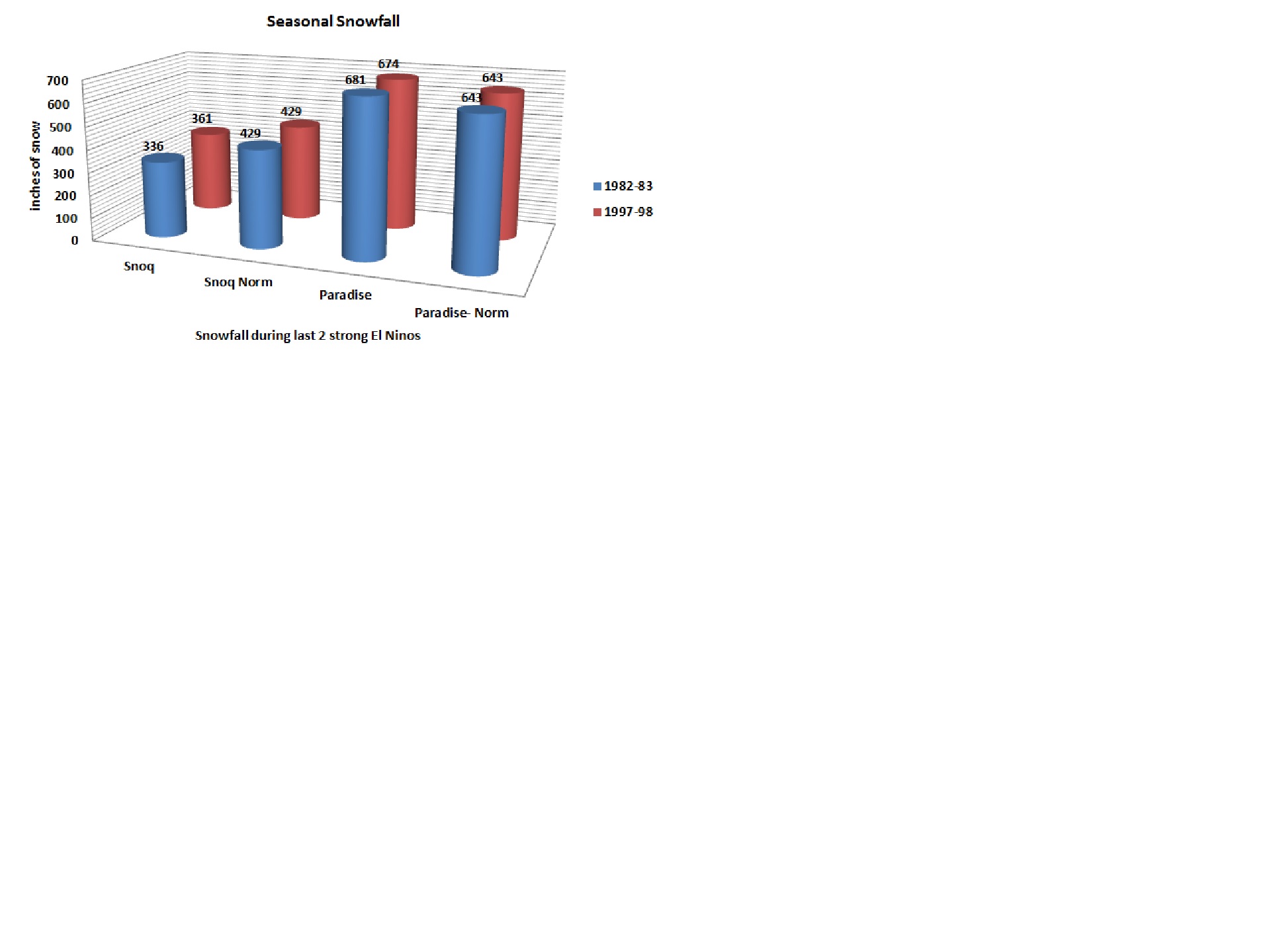
The chart below shows the amount of snowfall for the last two strong El Nino phases, 1982-83 and 1997-98. For Snoq Pass snowfall as a percent of normal was 78% and 84% respectively while for Paridise at Mt. Rainier it was 105% and 104% respectively. What will happen this season. Time will tell and we will update you.