Atmospheric Rivers
By Michael FaginGeneral Info, Historical Weather Data, Weather ExpertWith 0 commentsAtmospheric rivers (AR) are long and narrow bands of highly-concentrated moisture in association with winter storms and occur throughout the middle latitudes near major oceans. Thus the US West Coast is subject to this.
The amount of moisture can be extreme especially when the air is forced up the mountains along the West Coast. How much? According to NOAA “A strong AR transports an amount of water vapor roughly equivalent to 7.5–15 times the average flow of liquid water at the mouth of the Mississippi River.”
This water vapor graphic shows just how much moisture that can be transported. 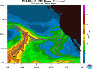
The bright orange from the graphic above is the large plume of moisture being transported from the south. Depending on the source and air temperature this can bring the much needed snowpack into the Washington/Oregon Cascades and California Sierra. Much of this snowpack is the source of summer water needs for these regions.
However, if there is a long and deep fetch from the tropics this is called a subtropical moisture connection. This pattern has been called a “pineapple express” and can bring heavy rainfall along the West Coast and flooding can be common. Depending on the exact storm track the heavy rain can be targeted from at any one of the locations on the West Coast from California up to Washington and can also so north into Vancouver Island BC.
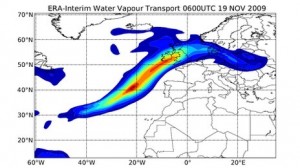
Are these AR just along the West Coast of North American Mid-Latitudes? No! There have been several papers on a storm in the Northwest England, Cumbria. This one storm in 2009 that continued for 24 hours brought some extreme flooding to the region. See water vapor graphic below.
Finally, over the last 30 years, there has been an average of 9-11 of the strongest atmospheric river events hitting Britain every year.